|
| |
|
| |
|
| |
|
| |
| |
| |
| |
| |
| |
| |

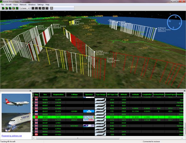
Aurora Virtual Radar 3D |
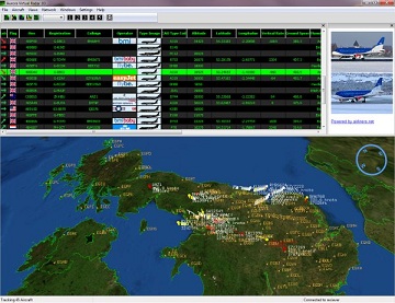 |   |
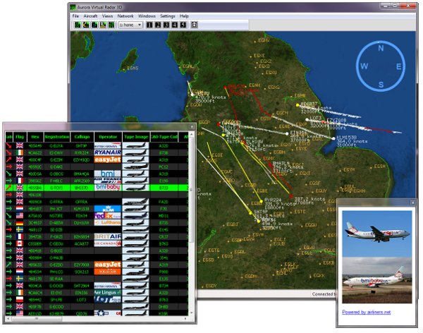
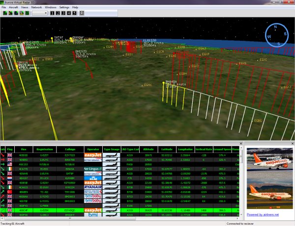
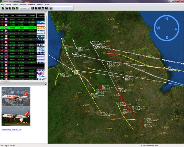
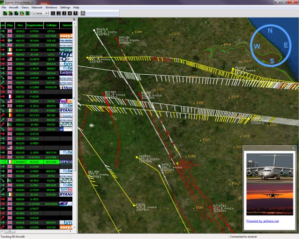
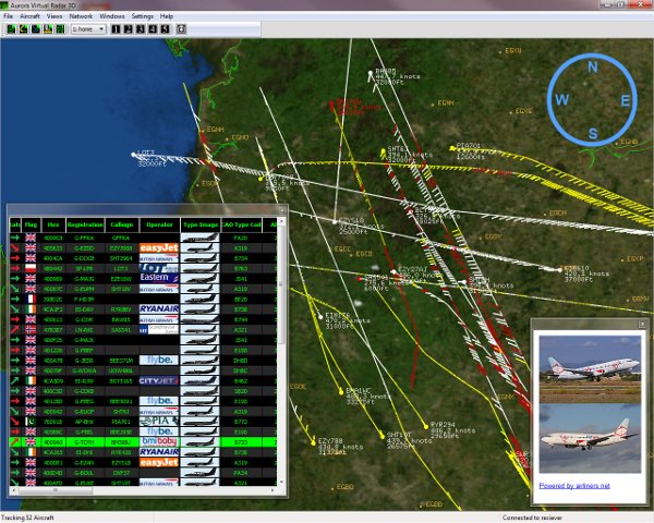
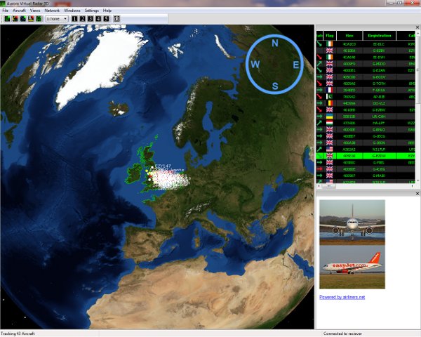
* Real Time 3D / 2D view of Mode-S/ADS-B tracked aircraft.
* Display Mode-A/C Codes.
* Aircraft Proximity Alert LED.
* NASA Maps.
* Aircraft Alerts.
* Photos of tracked aircraft.
* Support for dual monitors.
* Internet sharing.
* Screen capture.
* Automatic FTP upload of screen shots.
* Receiver outputs decoded messages with aircraft data. ie Hex,Alt,Lat,Lon etc.
To simplify development of users own programs.
* Raw data directly from receiver.
Time stamped to 25ns (using 64 Bit timer), for Hi-Precision Multilateration (MLat).
* Includes COAA Planeplotter Lite.
* Supports COAA Planeplotter MLat. Fully approved Ground Station.
* Compatible with third party applications. via port 30003.
* Uses SQLite open source database engine.
* SSRx Receiver uses advanced signal processing
(12bit 40Mhz ADC,FPGA and dedicated DSP).
* Suitable for all types of antenna.
incl mag-mount & hi-gain external (recommended).
* Size only 130mm x 81mm x 30mm.
* No external power supply required.
* Connects to Windows PC, Laptop via Plug & play USB connection.
* Support for third party developers.
We make Beta software available to both developers
and ALL our users for them to try our new features and developments.
(This is in addition to our full feature software and a
FREE copy of Planeplotter Lite)
* CE Approved.
| * Aircraft Range Estimation. | |
|
As well as being able to display the position of aircraft, there will be some aircraft that do not transmit their position and will only appear on the Aircraft List. With conventional Virtual Radar Receivers you do not know if the aircraft is 1/2 Mile away or 150 Miles away. Our Virtual Radar Receiver is differant, it has been optimised for measuring how far an aircraft is from the receiver, so you have an estimated distance for every aircraft in your Aircraft List. This opens up many possibilities, see examples below. a) You see an aircraft outside that you cannot identify but on the virtual radar there is only one displaying V Close * so you know exactly which aircraft it is. b) You know that the Vulcan or BBMF aircraft is on your Aircraft List but is it about to fly overhead or is it flying around 100 miles away? For users that have access to Planeplotter MLAT, it shows you the aircraft that are operating in your area that you might want to track. | |
| * Internet Sharing. | |
| Please Note: This is an experimental feature to test both our software and the network sharing server. | |
|
This feature introduces internet sharing with www.radarvirtuel.com We have designed the internet sharing feature to be true sharing, virtual radar users can share their aircraft positions with an aircraft tracking web site (radarvirtuel.com) and the website shares its aircraft positions with the virtual radar user. The software is designed to be simple to use, there is no requirement to make any changes to your router or firewall. By default the sharing is turned OFF and you must turn it ON when you start the Virtual Radar 3D software. Please Note:- * There will be times when the sharing server will be unavailable. * We expect there to be issues of some type with this software (it is experimental). * The main areas of the software we are working on at present, are the handover of aircraft between locally received aircraft and network aircraft and the Aircraft List, as it can have 2,300 aircraft at times. | |
| * Receiver range. | |
|
One question we get asked regularly is: What is the range of the Aurora Virtual Radar 3D? Unfortunately this is not an easy question to answer. In simple terms it depends on what is between the receiver antenna and the aircraft. For example if you live at the top of a hill and install an external antenna (and possibly a preamp) above your roof, then you could expect to get significantly over 200 miles. However, if you live in a city and place the supplied antenna on a first floor window, then you can expect 100 miles or less depending on buildings or hills around your house. The second question is: What is the maximum range for a good antenna location? Again difficult question, as it depends how good the location is and how the antenna is installed. When we carried out tests on our receiver we installed the supplied antennas to the roof of a car parked on open land at about 200ft above see level, our receiver range was about 180miles. | |
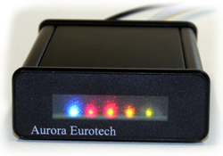
| * Aircraft proximity alert (Blue LED). | |
|
The blue LED on the front of the receiver indicates that an aircraft with ANY type of transponder (Mode-A/C or Mode-S) is within 5 to 10 miles.
| |
| * Display Mode-A/C Codes. | |
|
Mode-A/C messages from aircraft can contain either squawk (Mode A) or altitude (Mode C). It should be noted that there is no way of knowing which type of message type is being sent or the position of the aircraft. We also only display codes from aircrafts close to the SSRx Receiver. Information available from our receiver :- 1/ Squawk code. From this you can determine who is controlling the aircraft. i.e. squawk 6171 to 6177 indicates the aircraft is under the control of Doncaster Sheffield Approach There will also be a number of Mode C codes, these are of no significant use. 2/ Estimated distance to aircraft. Just like listening to pilots, Mode-A/C helps build up a mental picture of what is going on above our heads but it wont add any more trails to our screen. It should be noted that the Mode-AC display is still "A work in progress". | |
| * NASA Maps. | |
|
The NASA maps are installed with the Virtual Radar 3D, there is no need for an internet connection. The resolution of the maps we install changes for different parts of the globe. | |
| * Receiver outputs decoded messages with aircraft data. * Raw data directly from receiver. | |
|
We have made it easy for third party developers to use our SSRx Receiver. When the receiver is plugged into a Windows PC it appears as a standard serial port, you then have 2 options. 1/ Use the fully decoded text messages (example below). $!MSRAPA,,,,4ca0bc,37375,53.14268,-0.31424,,0,0,0,0,*00 $!MSRAPA,,,,4ca263,30700,53.35052,-1.10020,,0,0,0,0,*00 $!MSRAIC,,,,4ca263,,,RYR4026 ,*00 2/ The receiver can be switched into RAW mode, the SSRx Receivers output raw data with a 64bit time stamp. In fact you don't even need to install our software to access both decoded text messages or raw data. | |
| * No need to set the receiver Latitude/Longitude. | |
|
When decoding ADS-B position messages from aircraft there are 2 methods that can be used: 1/ Globally unique positions. The position for aircrafts can be found without knowing the location of the receiver. 2/ Locally unique positions. The position of aircrafts can ONLY be found if the receivers location is set accurately. Both methods have their pros and cons. SSRx Receiver uses ADS-B globally unique position to find the location of an aircraft, this means the receiver can be moved to different locations even different countries without the need to change settings in the software. In future versions of our software you will have the option of using either ADS-B globally unique positions or locally unique positions. | |
| * COAA PlanePlotter. | |
|
Our Virtual Radar 3D / SSRx is compatible with the PlanePlotter sharing network. And is fully approved as MLat Ground Station. | |
| * Min PC Specification. | |
|
We would recommend Pentium 4 / RAM 512MB / Hard Disk 1GB free / DVD Drive or better with Windows XP / Vista / Windows 7. As with other 3D software (ie Flight Simulators / Games / Google Earth) a modern graphics card is recommended. | |
 |
 |
 |
 |
 |
 |
 |
 |
| Please note :- 1/ Some of the Operator Logos / Aircraft Silhouettes are not included with the Virtual Radar 3D but can be downloaded free from the internet. These are for demonstration purposes only. 2/ Aircraft photos are supplied from external websites. |
We aim to answer email questions within 24 hours.
| Q - Do we support Planeplotter? |
| A - Yes Our Virtual Radar 3D / SSRx is compatible with the PlanePlotter sharing network and is fully approved as MLat Ground Station. Planeplotter works directly with our SSRx receiver or via port 30003. We include a copy of Planeplotter Lite with the Virtual Radar 3D. |
| Q - Can I use outlines / flags that are available on the internet? |
| A - Yes. And if you have created any outlines / flags etc, that you would allow us to use please contact us by email. We are keen to support third party developers. |
| Q - Can I write my own software to work with your receiver? |
| A - Yes. Its as simple as reading the data coming out of a serial port GPS.
Protocol information will be published when we start shipping our Aurora Virtual Radar 3D.
|
| Q - What database do you use. |
| A - SQLite.
|
| Q - Can the firmware in the receiver be updated? |
| A - Yes the firmware for both the FPGA and the DSP can be updated.
|
| Q - Do I need Google Earth for 3D view? |
| A - No When we designed our Virtual Radar we looked into using Google Earth and for the reasons below we made the decision to write our own 3D Virtual Earth Software. We do not use Google Earth for the following reasons :- * Our Virtual Radar is designed to be a TRUE real time system (see below). If we used Google Earth there would be a significant delay between the aircraft sending its position and the screen displaying the aircrafts new position. This may be as low as 5 or 10 seconds but may be significantly over 30 seconds for customers without a high spec PC. We believe it is unacceptable that a customer would be watching an aircraft preparing to take off on their Virtual Radar and at the same time seeing it flying off into the distance in real life. * Our Virtual Radar is designed to operate without an internet connection. There are problems using Google Earth without a broadband connection. * There is a risk that Google may update Google Earth in a way that is not compatible with our software. * Having read ALL Google terms and conditions for the use of Google Earth, there are a number of significant licencing issues if we embed Google Earth into a product that will be sold. However just to be clear, in our view Google Earth is an excellent product for NON REALTIME applications. |
| Q - What do you mean by Real Time? |
| A - We consider Real Time to mean that if you can see an aircraft take off with your eyes, then what you see on the computer should be delayed by less than 1 second. This also applies to data sent to third party programs ie. Planeplotter. ALL our data is sent LIVE, Update 16th Nov 2009 - After announcing our Virtual Radar 3D to dealers this morning, Kinetic have released an update to remove the 5 Minute delay from their Basestation software this afternoon. Update 23rd Nov 2009 -Airnav have removed the 5 Minute delay from their Virtual Radar. This is good news for everyone. |
| Q - Is there a subscription for NASA Maps? |
| A - No. |
| Q - Do I need an internet connection? |
| A - No. Operating without an internet connection was a priority in our design.
Internet is only required for sharing / updates. |
| Q - Do we support MAC / Linux? |
| A - Windows only at present. |
| Q - How long is the warranty? |
| A - 12 Months return to us or to the dealer. |
| Q - What is the history of this product. |
| A -A little history. In the Yorkshire/Lincolnshire area there were a number of serious horse riding accidents reportedly caused by low flying helicopters. In 2005 we carried out development with the aim of warning riders of the proximity of low flying aircraft. In fact the technology we developed allowed us to track aircrafts using Mode-A and Mode-C as well as Mode-S transponders with a very high degree of accuracy. However due to commercial and licensing issues this was not developed into a full blown product and network. Then at the end 2008 of we made the decision to develop this technology into several commercial products. The first is our Aurora Virtual Radar 3D. You will find the following relevant:- 1/ Military Helicopter Low Flying Safety, A Guide For Riders. http://www.mod.uk/NR/rdonlyres/1B6186D9-6137-43D5-B7D1-1D81EE4D8E5F/0/uklfs_heli_safety_guide.pdf 2/ ARMED FORCES (PARLIAMENTARY APPROVAL FOR PARTICIPATION IN ARMED CONFLICT) BILL I will quote :- There have, to date, been three deaths. In 1996, Alexandra Nixon died. In June 2003, Heather Bell was killed when riding along a bridleway when her horse was spooked by a low-flying Chinook. In December 2003, Melanie Dodds was killed when her pony was startled by a low-flying military helicopter and the horse ran into two cars. In 2004, the Ministry of Defence agreed to pay compensation to Sacha Jane Smith, an event rider who was badly injured when her horse was spooked by low-flying jets. Her gelding reared and fell into a ditch, badly damaging his legs, flattening her pelvis, breaking her ribs and injuring her back. http://www.parliament.the-stationery-office.co.uk/pa/cm200405/cmhansrd/vo050304/debtext/50304-20.htm |
| Q - Can you produce a custom version of this product for us. |
| A - We can develop custom versions of our products or design new products to your requirements. Waddicor Associates / Aurora Eurotech have been developing custom products for clients since 1993. Visit Waddicor Associates Web Site http://www.waddicor.com |
For Beta or Release Candidate software please go to the Developer Download Centre.
Virtual Radar 3D
Virtual Radar 3D
Ver 1.1.4.10
Virtual Radar 3D -------------------------------------------------
SSRx Receiver Update
Ver 1.2.2.18A
(4 February 2013)
Recommended for Distance Estimates of Mode-S Aircraft (Mode-AC Disabled).
Firmware update for SSRx Receiver.
* It is normal to have to run the updater twice to update the SSRx.
-------------------------------------------------
SSRx Receiver Update
Ver 1.2.2.10A
(4 February 2013)
Recommended for users interested in Mode-A/C.
Firmware update for SSRx Receiver.
* It is normal to have to run the updater twice to update the SSRx.
-------------------------------------------------
DBImporterTool
Ver 1.1.1 Beta
DB Importer
For importing BaseStation.sqb into Virtual Radar 3D.
Read me file
DB Importer - Readme.
PlanePlotter
Planeplotter Lite
Ver 5.5.1
Planeplotter Lite software is provided by
COAA
-------------------------------------------------
Aurora SSRx / PlanePlotter Guide
User Guide
Issue 1.0.0.2
Aurora Virtual Radar 3D Receiver / PlanePlotter Guide.
Setting up COAA PlanePlotter for your Aurora SSRx Receiver as a Mlat Ground Station.
Please check for regular updates to this guide.
Virtual Radar 3D - Archive
Virtual Radar 3D
Ver 1.0.6-8
Virtual Radar 3D.
This release introduced "Distance Estimates" to aircraft that cannot be tracked.
With with SSRx Firmware Ver 1.2.2.18 significantly increases the number of aircraft.
Please note:-
* Software WILL be updated without notice.
* ALWAYS keep an up to date backup.
| Description | UK Price (Ex VAT) |
UK Price (Inc VAT & Shipping) |
Europe (Non UK) Price (Inc VAT & Shipping) |
Non European Price (Inc World Wide Shipping) |
| Virtual Radar 3D SSRx Receiver and software. | £299.00 | £358.80 Out Of Stock | £376.80 Out Of Stock | £334.00 Out Of Stock |
Please Note :-
* All our products are CE appoved for sale within Europe.
* Our products MUST NOT be used for safety of life or navigation activities
Export Policies
1) Non EU Customers. You will be responsible for Customs Clearance and possibly Import Duty.
2) We ship to most international locations. We currently do not ship to:
Afghanistan,Azerbaijan,Belarus,Burma,Democratic Republic of Congo,Cuba,North Korea,
Iran,Iraq,Ivory Coast,Lebanon,Liberia,Libya,Myanmar/Burma,Republic of Guinea,Rwanda,Sierra Leone,
Somalia,Syria,Sudan,Zimbabwe,Yemen,West African States.
3) You will not forward the items to one of the countries listed above.
Note : SSRx Receiver and software only is for use with your own antenna or antenna supplied by another company.
| (c)Aurora Eurotech 1993-2022 All Rights Reserved. Aurora Eurotech is a division of Waddicor Associates. |